Tuesday, December 11, 2012

Snowfall in the Upper Midwest reached up to 16 inches in some regions over the weekend of the December 8 and 9, 2012. Many people were thrilled about the snowfall since last year this region was robbed of its usually snowy and snow recreational filled season. Many people got outside doing the things they love like skiing, while others have gotten in the wintery spirit thinking about the upcoming snowmobile season. Many stores have also had good fortune from the snow by selling a lot of snow shovels, ice melt, and "hundreds" of snow-blowers since Sunday's snow.

People enjoying the snow

However, not everyone is as happy and 
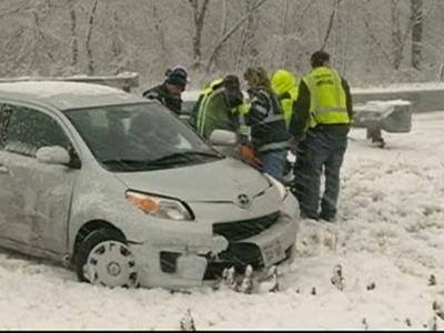
fortunate for the snow. The snow caused slippery roads that were blamed for hundreds of crashes and at least two deaths from Minnesota to Oklahoma, and two other deaths were related to the wintry weather.
The Minnesota State Patrol reported more than 600 crashes by Monday morning, and at least 1,140 spinouts. One person was killed Sunday in a crash involving a semi near Red Wing, Minn. And in New Prague, school officials said a 54-year-old social studies teacher at the middle school died while shoveling snow at his home Sunday.
In southern Oklahoma, a Dallas man was killed early Monday when he lost control of his sport utility vehicle on an icy bridge on Interstate 35.
In Kansas freezing overnight temperatures may have contributed to the death of a 30-year-old woman whose body was found in a field early Monday.

Even Texas got a taste of winter, as an arctic blast dumped up to 5 inches of snow in parts of West Texas and dropped temperatures into the teens in part of the Panhandle. Strong winds cut electricity to about 3,000 homes and businesses in Austin, but reports said all but a handful of customers had power restored by midday Monday.

And other people not enjoying the snow

Blizzards are a natural hazard that happen in the Upper Midwest region, people know this and know what precautions need to be taken to prevent injury and death, especially on the roads. A lot of the car accidents and spinouts could’ve been prevented if people would drive slower, take safer driving precautions, or if they would just stay off the roads. This doesn’t really qualify as a disaster, but a lot of this could’ve been prevented if the proper safety and mitigation measures would’ve been taken.

It goes back to the Swiss cheese model; it only gets worse when factor after factor plays a role. The snow alone is not a threat, it’s the decisions people make when there is heavy snow and ice that increases the risk to them.

Image Source: http://bloximages.chicago2.vip.townnews.com/azstarnet.com/content/tncms/assets/v3/editorial/0/99/099f7ae8-424b-11e2-9a0e-001a4bcf887a/50c508a694cd0.preview-620.jpg
http://videos.usatoday.net/Brightcove2/29906170001/2012/12/29906170001_2025364779001_1210dv-midwest-snow-400x300.jpg?pubId=29906170001


Gas Explosion in Sissonville, West Virginia


Natural gas explosion that took place on interstate 77 at 1pm in Sissonville, West Virginia on December 11, 2012

In Sissonville, West Virginia Tuesday December 11, 2012 a natural gas line exploded in an hour-long blaze burning homes and roads. At least five homes went up in flames and a section of Interstate 77 was badly burned. This event would be categorized as a technological hazard. A technological hazard result in man-made accidents because the trigger event in human action, or inaction, when dealing with dangerous technologies; thus these hazards arise not simply from faults in technology alone but are linked to human fallibility in decision-making. At this point the company is still gathering facts to understand what took place to cause the explosion.
After the explosion a shelter/gathering area was set up at the Sissonville High School where several people were treated for smoke inhalation and a press conference was planned for later in the afternoon. Thankfully no one has been reported as seriously injured at this point.

Post-disaster mitigation took place as the interstate, which was ‘cooked’ by the explosion, was shut down while engineers and inspectors repaired the damaged and assess whether a bridge on the route was compromised.

This explosion could’ve been a lot worse if other factors/ features were at the wrong place at the wrong time, referring to the Swiss cheese model. For example the explosion took place less than a mile from a nursing home. If the blast had been closer, residents living at the home could’ve been badly injured or even killed. Other examples could be that there could’ve been a hazardous material site located near the explosion which could’ve acted like a chain reaction, one explosion leading to another. With more than one explosion there would’ve been more of a possibility of people being seriously injured or killed.

Image Source: http://wowk.images.worldnow.com/images/20317484_SS.jpg


Monday, December 10, 2012

Dense Fog in China Causes Traffic Jams


This is an image of the dense fog in China which has caused serious traffic congestion and closure of some expressways.
Dense fog in north Chinas Hebei Province, east Chinas Shangdong and Jiangsu Province, has cause serious traffic congestion and closure of some expressways. In some areas visibility dropped to less than 1 km, or even below 500 meters in some areas, due to moderate rains, sleet and high winds. This has led to the death of at least 30 people and many others being injured in car pile-up accidents on the mist-shrouded expressways.
 
China is vulnerable to this dense fog event, especially on its expressways, due to its dense population. The more people there are on the road the more of a chance there is for accidents to take place.
In order to avoid additional injury and death from happening some parts of the western Shandong Province and the northern part of Jiangsu Province expressways were closed and traffic policemen were sent to direct traffic. Airports, expressways, and river ferries were cautioned to take necessary measures to ensure safety, as the Shijiazhang Airport was closed for hours due to the heavy fog. Residents living in those regions were also reminded of take precautions and reduce their outdoor activities.

Article and Image Source: http://dunyanews.tv/index.php/en/World/74382-Dense-fog-causes-traffic-jam-China


Strong Quake Strikes Japan

On Friday December 7, 2012 a 7.3 magnitude earthquake struck in the Pacific Ocean. This earthquake struck the same region of Japan devastated by last year's massive quake and tsunami, generating small waves but no immediate reports of heavy damage. Several people along the northeastern coast were reportedly injured and buildings in Tokyo and elsewhere swayed for several minutes. The epicenter was 6.2 miles beneath the seabed and 150 miles offshore.
To prevent this natural hazard from turning into a disaster authorities issued early warnings that a tsunami potentially as high as 2 meters could hit. To do this the Meteorological Agency has an early warning system that, using data from seismographs scattered across Japan, enables it to provide advance warning of the estimated intensity and timing of a major quake.
Extra safety precautions were taken as two of Japan's 50 nuclear plants are currently operating; the rest have been shut down for maintenance and safety checks.
Damage and death from these tsunamis could be prevented if communities didn’t build on coastal areas that are prone to earthquake and tsunami events.

Article Source: http://www.duluthnewstribune.com/event/article/id/251994/group/News/

Monday, December 3, 2012

2012: One of the Most Active Hurricane Seasons


Satellite image captured on October 31, 2012 as Hurricane Sandy’s circulation was winding down over Pennsylvania. (Photo was taken by NASA GOES Project).

2012 is being named one of the most active hurricane seasons ever. There were 19 named tropical storms this year in the Atlantic Ocean basin tying 2012 at third for most named-storms in recorded history. The top spot goes to the 2005 season, which saw 28 named storms.  While being one of the busiest on record, the 2012 season also saw weaker-than-average cyclones and began earlier than usual.
The United States has not been hit with a major hurricane since 2005, by far the longest respite on record. While major hurricanes were scarce this year, storms still caused major damage, particularly Hurricane Sandy. That storm killed 125 people in the United States, and another 71 people in the Caribbean, including 54 in Haiti.

The large number of hurricanes seen this season resulted, in part, from above-average surface temperatures throughout the Atlantic, conditions which help cyclones form. Temperatures reached about 6 degrees Fahrenheit (3 degrees Celsius) above average this summer. Also, air higher up in the atmosphere also got warmer than usual. This helped to cap the storms' strength; hurricanes intensify the most when the upper atmosphere stays cool. The difference between the warm surface and cool atmosphere provides strength to cyclones, which function like giant heat engines.

In its first hurricane season forecast, made before the season began, the National Oceanic and Atmospheric Administration predicted nine to 15 named storms. Then, in August, the organization upped its prediction to 12 to 17 named storms, with five to eight of those becoming hurricanes. The revision was based on changes to climate patterns that affect storm formation. A tropical storm becomes a hurricane once its top winds hit at least 74 mph (119 kph). The 19 named storms this season beat even the revised prediction. It's relatively unusual to have more storms than forecast. The underestimate can be blamed on El Niño, or rather, the lack of El Niño, when Hurricane Sandy formed. Forecasters predicted that this weather pattern, characterized by cool surface temperatures in the Pacific Ocean, would have developed by the fall. But it didn't. Therefore, cyclone activity continued longer than expected in the Atlantic, unperturbed by El Niño, which spawns high level winds that stream eastward and can disrupt the swirling motion that gives a developing storm its power.

Global warming likely isn't to blame for the increase in hurricanes. Many climate models suggest that increased temperatures could lead to fewer, but stronger hurricanes worldwide, essentially the opposite of what we saw this year.

Better technology also allows us to detect more hurricanes than in the past. In the past few decades, satellites have significantly increased the detection of short-lived tropical storms, i.e. ones that last fewer than 36 hours.

This year's season ended with Hurricane Sandy, which caused widespread devastation thanks to a tremendous storm surge throughout New Jersey and New York. Sandy will go down as the second costliest storm in U.S. history. This storm was unusual, as the first storm to retain hurricane strength north of the jet stream, the wind pattern that moves air from west to east across North America and into the Atlantic. Sandy also registered the lowest barometric pressure in the history of the Northeast. Once it moved north of the Gulf Stream, Sandy interacted with a mass of cold air moving east across the continent, causing it to transition to an extra-tropical storm and wreak so much devastation.

Scientists are still studying Sandy to understand how it formed, and whether or not climate change might have contributed. It could be a freak thing, or we could be going into a new climate regime where we're likely to see more impacts like this in the future.


Third Major Storm Moving Into California

Northern California has been in the line of powerful and destructive storms that have been passing over them for the past week. As of late Saturday and early Sunday the third storm system hit the area with pounding rain and strong winds. With as much as an inch or rain falling per hour in some areas trees have been falling down taking out much of the electrical service to tens of thousands of people. Along with the rain has come the swelling from the deluge of rivers across the area. Preparation and weather forecasting have been in effect for flooding of the Napa and Russian rivers, two rivers north of San Francisco with a history of flooding; as well as the Truckee River, near Lake Tahoe. Preparation started on Thursday with city officials had handing out more than 8,000 sandbags and about 150 tons of sand, while Truckee officials had set up an evacuation center in a school district building. On top of that about 2,000 PG&E crews have been working to restore power to the area.

This image was taken November 30, 2012 of a crew from Vaccaro Tree Services removing a fallen tree along Hickory Road in Fairfax, California.

Article and Image Source: http://www.foxnews.com/weather/2012/12/01/third-major-storm-moving-into-northern-california/?test=latestnews

Monday, November 26, 2012

Holding Back Floodwater with a Balloon

This is image of the balloon engineers are developing as protection for subway tunnels and underground highways
Scientists are working to develop a new type of protection for subway tunnels and underground highways.

This new mitigation strategy is a rather simple idea, rather than retrofitting tunnels with metal floodgates or other expensive structures, the project aims to use a relatively cheap inflatable plug to hold back floodwaters. In theory, it would be like blowing up a balloon inside a tube. But in practice, developing a plug that is strong, durable, quick to install and foolproof to deploy is a difficult engineering task, one made even more challenging because of the pliable, relatively lightweight materials required. “Water is heavy, there’s a lot of pressure,” said Greg Holter, an engineer with Pacific Northwest National Laboratory who helps manage the project. “So it’s not as simple as just inflating and filling the space. The plug has to be able to withstand the pressure of the water behind it.”

This is an example diagram of what the balloon is made out of and how it will work

This device will help guard tunnels during real disasters whether it be a terrorist attack or a storm like Hurricane Sandy.
This new device is an example of the engineering paradigm, whose approach is focused on protection strategies, like making all built structures sufficiently strong to withstand a direct hazard confrontation.

Article Source: http://www.nytimes.com/2012/11/20/science/creating-a-balloonlike-plug-to-hold-back-floodwaters.html?ref=science
Image Sources: http://www.nytimes.com/pages/science/index.html


Hurricane Sandy Damage Amplified by Development of Coast

This article discusses the devastation Hurricane Sandy had New York and New Jersey. It also discusses how the scale of the storm could have been lessened if proper planning and zoning had been enforced
Given the size and power of the storm, much of the damage from the surge was inevitable, but not all of it. Some of the damage along low-lying coastal areas was the result of years of poor land-use decisions and the more immediate neglect of emergency preparationson coastal areas and barrier islands. Authorities in New York and New Jersey simply allowed heavy development of at-risk coastal areas.
On Staten Island alone, developers built more than 2,700 mostly residential structures in coastal areas at extreme risk of storm surge flooding between 1980 and 2008, with the approval of city planning and zoning authorities. Some of this construction occurred in former marshland along the island's Atlantic-facing south shore. The city allowed development and growth to happen in areas that probably shouldn't have been developed," said Jonathan Peters, a professor of finance at the College of Staten Island. "I think the fact is that you put a lot of people in harm's way with the zoning." Developers built up parts of the Jersey Shore and the Rockaways, a low-lying peninsula in Queens, N.Y., in similar fashion in recent years, with little effort by local or state officials to mitigate the risk posed by hurricanes.

This article does a good job at explaining how the intensity of the development along the coast clearly influenced the scale of the disaster.


Monday, November 5, 2012

Cuba's Recovery After Hurricane Sandy

As Manhattan begins to recover after hurricane Sandy with subways up and running and lights shining down on the city Cuba continues to struggle with getting power restored. On October 25, 2012 Hurricane Sandy swept through Cuba as a Category 2 hurricane. At this time, November 5, 2012, only 28 percent of the city of Santiago’s electricity grid has been restored. Although they have crews working around the clock to restore energy to homes and businesses it is estimated that electricity won’t be fully restored until November 15. Although both Cuba and New York have high population densities causing them both to be vulnerable to storms Cuba is LDC whereas New York is MDC making recovery from the storm easier for New York. New York is receiving extremely high volumes of media coverage which makes receiving aid easier compared to Cuba who isn’t receiving as much media coverage and is recovering much slower than New York. Cuba also sustained major losses of coffee and other crops which will make long term economic recovery a struggle. More than 200,000 homes and 129 schools were destroyed leaving many without homes and children having to attend school in private homes. This will cause the reconstruction period to be long term. It will also, more than likely, create an indirect gain of jobs.

 
This is an image of residents in Santiago, Cuba walking through the rubble left from Hurricane Sandy on October 26, 2012
Image Source: http://ww2.hdnux.com/photos/15/73/51/3652213/3/628x471.jpg

Friday, November 2, 2012

Hurricane Sandy Hits New York

Residents located on the east coast the United States are experiencing the wrath of post-disaster effects caused by hurricane Sandy. This densely populated metropolitan region, especially that of New York City, is experiencing an extremely high volume of media coverage as residents begin a massive clean-up effort due to hurricane Sandy.  At this point many businesses and homes are still without any power or modes of transportation.  Sandy caused more than 8.2 million households, where nearly 2 million of them were located in New York, in as many as 17 states to be powerless. It also left 7 seven subway tunnels and streets between Manhattan and Brooklyn to be underwater. Massive transit of more than 8.3 million busses, subways, and local railways were shut down leaving many who rely on city transportation stuck. Sandy also caused more than 18,000 flights to be cancelled. HIS Global Insight in estimating that the storm left around $20 million in damages and about $10-$30 billion in business loss. Sandy was also the cause for the New York stock Exchange to be closed, this is the first time this has happened since 1888.


These area images showing flooding of streets and subways in New York due to Hurricane Sandy


Sandy couldn’t have come at a more controversial time. Sandy hit just a week before the Nov. 6, 2012 presidential election leaving President Obama and his opposing candidate Mitt Romney forced to cancel campaigning in order to assist in relief efforts. Response from President Obama was especially imperative at this time to prove to the country he’s on top on government aid and disaster relief. Obama issue federal emergency orders for both New York and New Jersey, declaring “major disasters” existed in both states.

These images show destruction the that overtook New York in regards to Hurricane Sandy


Since the disaster has left many without power, transportation, or even a place to live it getting to the polls to vote Tuesday could be difficult for many, especially those who are most vulnerable which include the elderly, the low-income class, and the poor. This effect will without a dought have an impact on voting outcome.
Article Source: http://t.news.msn.com/us/sandys-us-toll-climbs-to-50-82-million-without-power
Image Sources: http://www.csmonitor.com/var/ezflow_site/storage/images/media/content/2012/1030-sandy-new-york-city/14175113-1-eng-US/1030-sandy-new-york-city_full_600.jpg
http://static3.businessinsider.com/image/509139d1eab8eaac1d000006-800-534/new-york-hurricane-sandy-flooding-subway.jpg
http://timemilitary.files.wordpress.com/2012/10/gal-hurricane-sandy-01.jpg?w=720
http://www.csmonitor.com/var/ezflow_site/storage/images/media/content/2012/1030-hurricane-sandy-aftermath-flooding-rain/14176087-1-eng-US/1030-HURRICANE-SANDY-AFTERMATH-FLOODING-RAIN_full_600.jpg


Surfing Sandy

An image of recreational dare devils surfing waves on Lake Michigan due to high winds caused by Hurricane Sandy


Hurricane Sandy brought some unexpected media coverage to Lake Michigan Tuesday October 30, 2012. Jim Hoop, a 50-year old real estate agent and former lifeguard, takes every opportunity given him to surf waves on Lake Michigan. Waves with surfing potential like the 20-foot waves caused by 54 mph winds on Tuesday only happen about once a year on Lake Michigan, and are normally caused by winter storms. These waves were caused by an unusual scenario, they were the outcome of hurricane Sandy who was more than 600 miles away on the east coast. Wind and waves were so extreme in this area they caused 1,000 foot freighters with loads of iron ore, coal, and other bulk commodities to take refuge in the harbors to escape the storms wrath.

This image shows waves that got as high as 20 feet on Lake Michigan due to Hurricane Sandy

When we think about this scenario in terms of risk assessment we can consider Jim’s actions of surfing the 20-foot waves as a voluntary risk, he was aware of the danger he was putting himself in and did it anyways. We can also calculate the risk, risk = hazards * element at risk * vulnerability, here the hazard would be the high waves, the element at risk would be Jim and the vulnerability would be him placing himself in the way of the dangerous waves.

Despite his Knievel like ways Jim came out of the lake safe and will more than likely continue to ride waves on Lake Michigan in the future.

Article Source: http://www.duluthnewstribune.com/event/article/id/248281/group/News/

Image Sources: http://kmsp.images.worldnow.com/images/19941289_BG1.jpg
http://media.mlive.com/kzgazette_impact/photo/11777052-large.jpg


Wednesday, October 24, 2012

Hurricane Sandy

Satellite image of Hurricane Sandy’s path from Monday Oct. 22 to Wednesday Oct 24, 2012
Hurricane Sandy developed on Oct 22, 2012 in the Atlantic Ocean. Sandy started off as a tropical storm and formed in to a category 1 hurricane. Sandy, who was about to make landfall along Jamaica’s southeast coastline on Oct 24, has been predicted by forecasters to eventually hug the East Coast and possible even make landfall in the Northeast. That scenario is likely to play out if the jet stream curves back and allows for it to happen. If that happens the Northeast would likely see 10-12 inches of rainfall along the Eastern Seaboard. While Sandy was located 30 miles south of Kingston, Jamaica’s capital, it was moving north at 14 mph and winds as fast as 80 mph. Jamaican schools were closed and shelters were opened to residents of flood-prone areas ahead of the potential landfall. Satellite radar showed that Sandy was on a projected path to cut through the middle of Jamaica, near Kingston, then the north coast of Ocho Rios and finally passing over eastern Cuba before losing strength as it reaches the Bahamas. If that happens Sandy could dump 6-12 inches of rain on these areas, and some up to 20. These rains could produce life-threatening flash floods and mudslides, especially in areas of mountainous terrain.
 
 
This is an image of waves crashing into Kingston, Jamaica from Hurricane Sandy on Wednesday Oct. 24, 2012.

Sandy is considered a small hurricane but the geography, location, and population density of these places make them vulnerable. Adaptation such as weather forecasting and early warnings, along with protection measures such as flood management and shelter areas will help prevent this natural hazard from becoming a disaster.

Lorca Earthquake

Scientists have been studying the cause of an earthquake that took place in the Spanish city of Lorca in 2011. This particular earthquake wasn’t very large, only a 5.1 magnitude quake. It took place at a depth of only 3 km which in turn caused a lot of damage and killed nine people. What scientists found after examining satellite radar data was that the slippage of the fault took place at a location where the water table, which is located next to a large water basin,  had been dropped over 250m over the last 50 years due to drilling and irrigation.  Scientists said that this is a seismically active region and earthquakes are bound to happen regardless, however the draining of the water sped up the process, created stresses on the fault and initially triggered the earthquake and defined its magnitude.  

Scientists say that seismic activity that has been triggered by human activity that are located near faults have been documented over the years. Other forms of activities that take place to trigger earthquakes include the impoundment of reservoir lakes, hydrocarbon extraction, quarrying and deep well injections. Scientist hope to be able to tame natural faults through geoengineering if they are able to understand how stresses from human activity contribute to seismic events. 


This image shows damage that took place from the 5.1 magnitude earthquake in Lorca on May 12, 2011
Article Source: http://www.bbc.co.uk/news/science-environment-20025807
Image Source: http://news.bbcimg.co.uk/media/images/52671000/jpg/_52671579_jex_1043138_de27-1.jpg


Friday, October 19, 2012

Oklahoma Dust Storm

This is an image which shows the dust storm was so dense that it was able to be identified from a high resolution satellite
 

 This image shows visibility range though the dust clouds
 

On Thursday, Oct. 18, 2012 a dust storm in Northern Oklahoma caused a multi-car accident and an 8 mile stretch of interstate 35 to be shut down. Visibility ranged less than 10 feet which lead to an accident involving nearly 3 dozen cars and tractor-trailers. Nine people were injured in the accident but no fatal injuries were sustained. This dust storm was caused by a mixture of several events, the main one being the drought our country has been experiencing this year, along with loose soils and high winds. Farmers are preparing for their winter harvest of wheat which involves loosening the top soil of their fields. With the drought the soils are so dry and with the top solid being loose it’s almost like a powder consistency. Combine these two elements with high wind speeds, like the ones experienced in Okalahoma and you have the perfect mixture for a dust storm.

This is an image of an accident that was caused by the low visibility from the dust
 

Article Source:
http://www.timesrecordnews.com/news/2012/oct/19/dust-storm-shuts-down-interstate-northern-okla/

Image Sources:
http://localtvkfor.files.wordpress.com/2012/10/dust-storm-kay-county-wind-marley-miller.jpg?w=579

http://cdn.washingtonexaminer.biz/cache/r620-24c52da7d04557ff5fa30739875a3bf8.jpg


Monday, October 15, 2012

Endangered Primate Species

Currently 25 species of monkeys, langurs, lemurs and gorillas are a severely threatened and are in danger of extinction. The cause is from an increasing amount of human activity related to deforestation and illegal trafficking and hunting. Of the 25 species of primates that are severely threatened 6 of the species are from the island of Madagascar, 5 from the mainland of Africa, 5 from South America, and 9 are in Asia. Lemurs are the most severely threatened with only 19 known individuals left in Madagascar. This is due to a dramatic change of power in the country since 2009 that has had a lack of enforcement. In all there are a total of 633 types of primates in danger of becoming extinct with the ones listed above being the most threatened. However, with the help of conservation efforts several species of primates are no longer listed as endangered. With that, conservation efforts have prevented a single primate species extinction in the 20th century or so far this century. Primates, who are mankind’s closest living relatives, are important because they contribute to the ecosystem by dispersing seeds and maintaining forest diversity. Primates have also become a popular ecotourism attraction and primate-watching is becoming a growing interest.
 
This is an image of a Madagascar lemur who is one the most threatened species at this time

Article Source: http://www.foxnews.com/world/2012/10/15/25-primate-species-in-africa-asia-reported-on-brink-extinction-from/
Image Source: http://www.foxnews.com/world/2012/10/15/25-primate-species-in-africa-asia-reported-on-brink-extinction-from/

Sunday, October 7, 2012

Mount Lokon Eruption in Indonesia

On Sunday October 7, 2012 Mount Lokon erupted in Jakarata, which is located in northern Indonesia. The eruption caused smoke and ash to discharge in the air leaving the cater with a cloudy cover. Heavy rainfall fell causing thick, heavy rain and mud in 6 nearby villages. Masks were provided to villagers by soldiers after the incident.  Nobody was injured or evacuated for the event because the nearest villages were beyond the area of danger. The 5,741 foot mountain inhibits more than 33,000 people living along its slopes. Mount Lokon is part of the archipelago of Indonesia that is prone to earthquakes and volcanoes because it sits on the Pacific “Ring of Fire”, a horseshoe-shaped series of fault lines. It is part of about 129 active volcanoes there. Mount Lokon’s last major eruption took place in 1991 killing a Swiss hiker and forcing thousands of people to flee their homes.

The eruption of Mount Lokon
 
Article Source: http://www.huffingtonpost.com/2012/10/07/mount-lokon-eruption-indonesia_n_1946219.html?utm_hp_ref=world

Friday, October 5, 2012

Landslide in China


Bodies of the 18 school children are searched for after the landslide

On Thursday October 4, 2012 a landslide hit Zhenhe, a village in Yunnan province in southwestern China leaving a total of 19 people dead. Eighteen of them were elementary school children who were attending class at the Tiantou Elementary School. The landslide dammed a river and caused a pool of water that was 45 feet across and 21 feet deep. This pool made rescue difficult and caused 800 people to evacuate. As of now the cause of the landslide is undetermined. This part of the Yunnan province has been hit with heavy rains is prone to earthquakes. Last month earthquakes left 81 people dead and devastated parts of the village. In China, Thursday was a National Holiday but children were attending classes to make up for days that were missed due to these earthquakes.

This area of China is prone to landslides due to the mountainous terrain, heavy rains, and earthquakes. Its dense population and low income make it vulnerable to disasters. If the country was able to provide proper mitigation strategies, such early weather forecasting, alerts before a natural hazard was to take place, better building structures, and so forth it, it would help reduce the impact these hazards have on the communities.

This picture shows rescuers searching for victims after the landslide

Article Source: 
http://abcnews.go.com/International/wireStory/landslide-hits-chinese-school-killing-19-students-17402495

Image Source:
http://msnbcmedia.msn.com/i/MSNBC/Components/Photo/_new/pb-121004-chinaLandslide-03.jpg  
http://msnbcmedia.msn.com/j/MSNBC/Components/Photo/_new/pb-121004-chinaLandslide-02.photoblog900.jpg


Monday, October 1, 2012

Pakistan Flooding

Victims of the flood
 
 
Within the last two weeks monsoon rains and flooding have caused more than 400 deaths, left nearly 3,000 people injured, and have affected more than 5 million people in Pakistan. Monsoon rains and flooding happen seasonally during the summer in this part of the country, but that last 3 years have been devastating. The worst flooding happened in 2010 where almost 1,800 people were killed and 20 million were affected.  Having been hit consecutively for the last 3 has made recovery difficult. Many are homeless and are limited on food, water, and shelter. The country and authorities have relied on international help to provide for those who have been affected by the floods.

These disasters are an example of how less developed countries are vulnerable to natural hazards and how they become disasters. Monsoon season is an annual occurrence and with proper mitigation strategies such disasters should be preventable, or at least limited. The high population densities and low monetary are two important factors in why this disaster continues to affect this country.
 
This image shows soldiers rescuing flood victims

Article Sources:
http://www.bbc.co.uk/news/world-asia-19763569

Image Sources:

http://cdn.muslimhands.org.uk/cdn/feature-images/470,353/media/17358167/01.jpg
http://www.globalpost.com/sites/default/files/imagecache/gp3_small_article/pakistan_monsoon_flood_09_29_2012.jpeg


Friday, September 28, 2012

Avalanche in Napal

Avalanche on Mount Manaslu in Nepal


On Sunday September 23, 2012 around 5:00 a.m. an avalanche on the mountain of Manaslu located in Kathmandu, Nepal killed at least 8 people. Three people are still missing and many others are injured. The avalanche struck two camping areas for mountaineers taking out 25 tents in one area and another 12 tents.  The mountain is 26,780 feet high and the two camps it hit were at 21,650 feet and 1,640 below. The avalanche was caused by a piece of ice, the size of 6 or 7 footballs fields, that fell from a glacier above them. Avalanches like these are known as objective hazards - a risk that cannot be controlled and one that climbers must accept.  Climbing season in the fall is more popular due to monsoon season covering the mountains in a lot of snow. Nepal has 14 of the highest peaks in the world which makes tourism for this popular sport bring in a lot of money for the country’s economy.  In the recent years the mountains have become somewhat crowded and more deaths are taking place due to amateur climbers and cheap climbing gear.  This incident was not connected to the number of climbers on the mountain but due to the amount of snowfall and the temperature of the ground. This natural hazard turned into a disaster due to the climbers present on the mountain at the time of the incident.

 
This is an image of rescuers and climbers preparing survivors for evacuation for the debris field of the avalanche.
 
Article Sources:
http://www.cnn.com/2012/09/24/world/asia/nepal-avalanche/index.html?hpt=wo_bn4
http://www.cnn.com/2012/09/24/world/asia/nepal-mountains-crowding/index.html

Image Sources: http://thumbnails.cbc.ca/maven_legacy/thumbnails/16/161/nepal-avalanche-brown-092412_lead_media_image_1.jpg
http://www.firstpost.com/wp-content/uploads/2012/09/NepalAvalanche_AP.jpg


Monday, September 24, 2012

Global Hawk Hurricane Hunter

This is an image of a Global Hawk plane

 NASA is using new technology to gather information and data from hurricanes to better understand and predict deadly storms. They are using planes which are referred to as Global Hawks and are flown unmanned, unlike the more commonly used manned hurricane hunter planes. Global Hawks have a wingspan of 116 feet, can stay in the air for up to 30 hours, and travel up to 11,000 miles. With these planes they will be able to use high altitude, long distance drones that can “spy,” or collect data, on the evolution of tropical storm intensity. These planes allow them to collect data that they aren’t capable of getting with manned aircrafts. The endurance of the drones is the difference between flying over and visually seeing the storm and the ability to monitor behavior, activities, and other changing information. NASA and others in collaboration with the project hope to document entire lifecycles of tropical storms in hopes to refine hurricane prediction and reduce the costs associated with both storm damage and evacuation.

This is an image of Tropical Storm Frank taken by a Global Hawk


Air Pollution in Europe

A new study released by the European Environment Agency (EEA) found that most residents of European cities are breathing toxic pollutants that are exceeding international health standards. Air found to be the most toxic is located in the eastern countries of Bulgaria and Romania; however, most urban areas contain unhealthy levels of pollutants like ozone, nitrogen oxides, and particulate matter. The main source of these pollutants stems from the transportation, energy, and agriculture. The unhealthy levels of pollutants can have widespread effects on both human and ecological health. Reports show that one third of city dwellers are exposed to excessive levels of airborne particulate matter. Reports also show that breathing unhealthy air may be the cause of nearly 500,000 premature deaths. Air pollution also has damaging effects on plants and can contribute to the corrosion of buildings. Reducing pollution in Europe has been an issue the countrys been working on; however, air pollution is still a major problem. This is causing some environmental and health advocacy groups to demand stricter regulations for air pollution which would make the EU standards sync with World Health Organization standards.
 
 
This image shows one of the many causes of pollution in Europe. This industrial plant is one of the many sources contributing to pollution in Europe. These plants affect almost every aspect of the biosphere, including: the atmosphere, land, rivers, and seas.

Image Source: http://www.hardrainproject.com/thumbnail.php?im=SP1108575.011.jpg&type=U