Satellite image of
Hurricane Sandy’s path from Monday Oct. 22 to Wednesday Oct 24, 2012
 Hurricane
Sandy developed on Oct 22, 2012 in the Atlantic Ocean. Sandy started off as a
tropical storm and formed in to a category 1 hurricane. Sandy, who was about to
make landfall along Jamaica’s southeast coastline on Oct 24, has been predicted
by forecasters to eventually hug the East Coast and possible even make landfall
in the Northeast. That scenario is likely to play out if the jet stream curves
back and allows for it to happen. If that happens the Northeast would likely
see 10-12 inches of rainfall along the Eastern Seaboard. While Sandy was
located 30 miles south of Kingston, Jamaica’s capital, it was moving north at
14 mph and winds as fast as 80 mph. Jamaican schools were closed and shelters
were opened to residents of flood-prone areas ahead of the potential landfall.
Satellite radar showed that Sandy was on a projected path to cut through the
middle of Jamaica, near Kingston, then the north coast of Ocho Rios and finally
passing over eastern Cuba before losing strength as it reaches the Bahamas. If
that happens Sandy could dump 6-12 inches of rain on these areas, and some up
to 20. These rains could produce life-threatening flash floods and mudslides,
especially in areas of mountainous terrain.
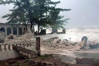
This is an image of
waves crashing into Kingston, Jamaica from Hurricane Sandy on Wednesday Oct. 24,
2012.
Sandy
is considered a small hurricane but the geography, location, and population
density of these places make them vulnerable. Adaptation such as weather
forecasting and early warnings, along with protection measures such as flood
management and shelter areas will help prevent this natural hazard from
becoming a disaster.
Article and Image Source: http://today.msnbc.msn.com/id/49533577/ns/weather/

No comments:
Post a Comment